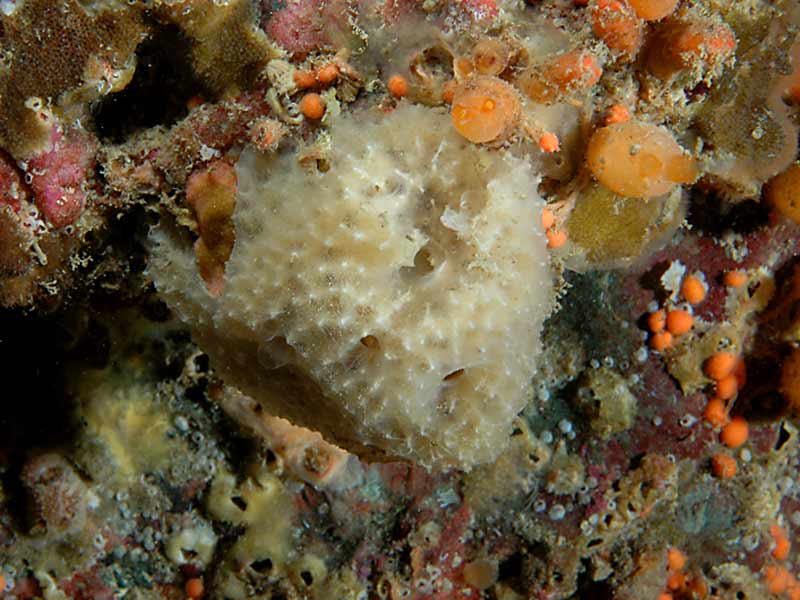
Goosebump sponge (Dysidea fragilis)
Distribution data supplied by the Ocean Biodiversity Information System (OBIS). To interrogate UK data visit the NBN Atlas.Map Help
| Researched by | Sonia Rowley | Refereed by | Admin |
| Authority | (Montagu, 1814) | ||
| Other common names | Goose bump sponge | Synonyms | Spongelia fragilis (Montagu, 1814) |
Summary
Description
Dysidea fragilis can be irregularly encrusting or massive and lobe-shaped. Encrusting forms may be up to 50 cm in diameter and 0.75 cm thick. Massive forms can be up to 30 cm in diameter. This species can vary in colour from brownish, greenish, greyish-white or reddish brown. The surface is covered in small conical projections (conuli) 1.5 mm in height and 2-2.5 mm diameter at the base. These conical projections are often lighter in colour. The exhalent openings (oscula) are scattered across the surface, can be slightly raised and vary in size from 2 to 5 mm in width. There are no spicules present and the skeleton is composed of spongin fibres making the consistency of Dysidea fragilis very elastic.
Recorded distribution in Britain and Ireland
This species is widely distributed around the coasts of Britain and Ireland but rare on the north east coast of Scotland.Global distribution
-Habitat
Dysidea fragilis is a cryptic species and can be found on the lower shore and sublittoral. It lives in rock crevices, on stones, shell and gravel. It has also been found embedded in muddy sand.Depth range
-Identifying features
- Encrusting or massive and lobe-shaped.
- Up to 50 cm in encrusting forms and 30 cm in massive forms.
- The surface covered in conical projections 1.5 mm in height.
- The oscula are scattered and up to 0.5 cm in diameter.
- No spicules present.
- Colour variable: brownish, greenish, greyish-white or reddish-brown.
Additional information
Dysidea fragilis has a distinctive smell and may be sandy in colour where sand dominates the substrata. Interestingly, larger specimens may be found in tidal, rocky esturanine areas, and specimens in northern waters tend to be smaller in size. The skeleton of this species is often partially or completely obscured by sand grains, spicules of other sponges, diatom valves, formainifera and other hard materials. Such materials may be incorporated in within the skeleton (Hayward & Ryland, 1995).
The barnacle Acasta spongites forms a specific association with Dysidea fragilis (Uriz et al., 1992). Dysidea fragilis may be mistaken for the very polymorphic Ulosa digitata, however, unlike Dysidea fragilis, Ulosa digitata has styles coring into its fibres (only visible under a microcope). Dysidea pallescens is a Mediterranean species also similar to Dysidea fragilis. Dysidea pallescens has is pink-purple in colouration with larger oscula and occurs in Lough Hyne, although may be found in other UK areas (Ackers et al., 1992).
Listed by
- none -
Bibliography
Ackers, R.G.A., Moss, D. & Picton, B.E. 1992. Sponges of the British Isles (Sponges: V): a colour guide and working document. Ross-on-Wye: Marine Conservation Society.
Bruce, J.R., Colman, J.S. & Jones, N.S., 1963. Marine fauna of the Isle of Man. Liverpool: Liverpool University Press.
Costello, M.J., Bouchet, P., Boxshall, G., Emblow, C. & Vanden Berghe, E., 2004. European Register of Marine Species [On-line]. http://www.marbef.org/data/erms.php,
Crothers, J.H. (ed.), 1966. Dale Fort Marine Fauna. London: Field Studies Council.
Gibson, R., Hextall, B. & Rogers, A., 2001. Photographic guide to the sea and seashore life of Britain and north-west Europe. Oxford: Oxford University Press.
Hayward, P., Nelson-Smith, T. & Shields, C. 1996. Collins pocket guide. Sea shore of Britain and northern Europe. London: HarperCollins.
Hayward, P.J. & Ryland, J.S. (ed.) 1995b. Handbook of the marine fauna of North-West Europe. Oxford: Oxford University Press.
Howson, C.M. & Picton, B.E., 1997. The species directory of the marine fauna and flora of the British Isles and surrounding seas. Belfast: Ulster Museum. [Ulster Museum publication, no. 276.]
MarLIN (Marine Life Information Network), 2005. SEArchable BEnthic Data (SEABED) Map [on-line]. Data Access Sub-programme, Marine Life Information Network for Britian and Ireland http://www.marlin.ac.uk,
MBA (Marine Biological Association), 1957. Plymouth Marine Fauna. Plymouth: Marine Biological Association of the United Kingdom.
Picton, B.E. & Costello, M.J., 1998. BioMar biotope viewer: a guide to marine habitats, fauna and flora of Britain and Ireland. [CD-ROM] Environmental Sciences Unit, Trinity College, Dublin.
Uriz, M., Rosell, D. & Maldenado, M., 1992. Parasitism, commensalism or mutualism? The case of Scyphozoa (Coronatae) and horny sponges. Marine Ecology Progress Series, 81, 247-255.
Datasets
Centre for Environmental Data and Recording, 2018. Ulster Museum Marine Surveys of Northern Ireland Coastal Waters. Occurrence dataset https://www.nmni.com/CEDaR/CEDaR-Centre-for-Environmental-Data-and-Recording.aspx accessed via NBNAtlas.org on 2018-09-25.
Fenwick, 2018. Aphotomarine. Occurrence dataset http://www.aphotomarine.com/index.html Accessed via NBNAtlas.org on 2018-10-01
Kent Wildlife Trust, 2018. Biological survey of the intertidal chalk reefs between Folkestone Warren and Kingsdown, Kent 2009-2011. Occurrence dataset: https://www.kentwildlifetrust.org.uk/ accessed via NBNAtlas.org on 2018-10-01.
Kent Wildlife Trust, 2018. Kent Wildlife Trust Shoresearch Intertidal Survey 2004 onwards. Occurrence dataset: https://www.kentwildlifetrust.org.uk/ accessed via NBNAtlas.org on 2018-10-01.
Manx Biological Recording Partnership, 2022. Isle of Man historical wildlife records 1990 to 1994. Occurrence dataset:https://doi.org/10.15468/aru16v accessed via GBIF.org on 2024-09-27.
National Trust, 2017. National Trust Species Records. Occurrence dataset: https://doi.org/10.15468/opc6g1 accessed via GBIF.org on 2018-10-01.
NBN (National Biodiversity Network) Atlas. Available from: https://www.nbnatlas.org.
Norfolk Biodiversity Information Service, 2017. NBIS Records to December 2016. Occurrence dataset: https://doi.org/10.15468/jca5lo accessed via GBIF.org on 2018-10-01.
OBIS (Ocean Biodiversity Information System), 2025. Global map of species distribution using gridded data. Available from: Ocean Biogeographic Information System. www.iobis.org. Accessed: 2025-08-08
South East Wales Biodiversity Records Centre, 2023. SEWBReC Marine and other Aquatic Invertebrates (South East Wales). Occurrence dataset:https://doi.org/10.15468/zxy1n6 accessed via GBIF.org on 2024-09-27.
Citation
This review can be cited as:
Last Updated: 12/09/2007


