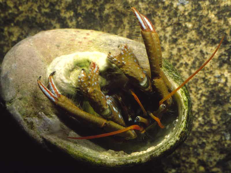
Mediterranean intertidal hermit crab (Clibanarius erythropus)
Distribution data supplied by the Ocean Biodiversity Information System (OBIS). To interrogate UK data visit the NBN Atlas.Map Help
| Researched by | Emily Wilson | Refereed by | Admin |
| Authority | (Latreille, 1818) | ||
| Other common names | Mediterranean rocky shore crab | Synonyms | - |
Summary
Description
A small hermit crab with short, thick pincers, more or less equal in size that have horny, black tips and are covered with hair. The carapace is longer than wide to 1.5 cm and the eyes are long and narrow.
Recorded distribution in Britain and Ireland
Channel Islands, formerly south coasts of Devon and Cornwall.Global distribution
-Habitat
Found in intertidal pools and on sand, gravel and algae in the shallow sublittoral to 40 m.Depth range
-Identifying features
- Carapace length about 15 mm.
- Rostrum small, acute, and slightly protruding.
- Chelae with thick fingers bearing thick horny, black tips and covered by wide, blunt tubercles and hair.
- Eyes extend slightly beyond antennal peduncles.
Additional information
No text entered
Listed by
- none -
Bibliography
Hayward, P., Nelson-Smith, T. & Shields, C. 1996. Collins pocket guide. Sea shore of Britain and northern Europe. London: HarperCollins.
Hayward, P.J. & Ryland, J.S. (ed.) 1995b. Handbook of the marine fauna of North-West Europe. Oxford: Oxford University Press.
Howson, C.M. & Picton, B.E., 1997. The species directory of the marine fauna and flora of the British Isles and surrounding seas. Belfast: Ulster Museum. [Ulster Museum publication, no. 276.]
Ingle, R., 1993. Hermit crabs of the northeastern Atlantic Ocean and the Mediterranean Sea. An illustrated key. London: Natural History Museum Publications, Chapman & Hall.
Datasets
Environmental Records Information Centre North East, 2018. ERIC NE Combined dataset to 2017. Occurrence dataset: http://www.ericnortheast.org.ukl accessed via NBNAtlas.org on 2018-09-38
Fenwick, 2018. Aphotomarine. Occurrence dataset http://www.aphotomarine.com/index.html Accessed via NBNAtlas.org on 2018-10-01
NBN (National Biodiversity Network) Atlas. Available from: https://www.nbnatlas.org.
OBIS (Ocean Biodiversity Information System), 2025. Global map of species distribution using gridded data. Available from: Ocean Biogeographic Information System. www.iobis.org. Accessed: 2025-08-08
Citation
This review can be cited as:
Last Updated: 04/07/2005


