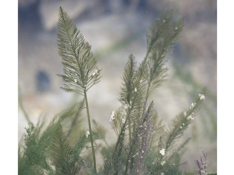
Hen pen (Bryopsis plumosa)
Distribution data supplied by the Ocean Biodiversity Information System (OBIS). To interrogate UK data visit the NBN Atlas.Map Help
| Researched by | Morvan Barnes | Refereed by | Admin |
| Authority | (Hudson) C.Agardh, 1823 | ||
| Other common names | - | Synonyms | - |
Summary
Description
Bryopsis plumosa is a large, feathery species of green seaweed. The thalli are erect, feather-like and may reach up to 15 cm in height. It is easily recognised by its delicate branches. All branches are regularly arranged in two rows on opposite sides of the central filament. The lengths of the branches decrease gradually from the base of the plant. It is usually dark to mid-green in colour.
Recorded distribution in Britain and Ireland
Widely distributed throughout British and Irish coastlines.Global distribution
-Habitat
Bryopsis plumosa is an epilithic species that is usually found in deep lower shore pools or subtidally in both sheltered and well-exposed habitats.Depth range
-Identifying features
- Dark green seaweed up to 15 cm in height.
- Feather-like thalli.
- Branches regularly aranged in two opposite rows.
- Branch length decreases gradually from the base.
Additional information
No text entered
Listed by
- none -
Bibliography
Burrows, E.M., 1991. Seaweeds of the British Isles. Volume 2. Chlorophyta. London: British Museum (Natural History).
Dickinson, C.I., 1963. British seaweeds. London & Frome: Butler & Tanner Ltd.
Hardy, F.G. & Guiry, M.D., 2003. A check-list and atlas of the seaweeds of Britain and Ireland. London: British Phycological Society
Howson, C.M. & Picton, B.E., 1997. The species directory of the marine fauna and flora of the British Isles and surrounding seas. Belfast: Ulster Museum. [Ulster Museum publication, no. 276.]
Datasets
Centre for Environmental Data and Recording, 2018. Ulster Museum Marine Surveys of Northern Ireland Coastal Waters. Occurrence dataset https://www.nmni.com/CEDaR/CEDaR-Centre-for-Environmental-Data-and-Recording.aspx accessed via NBNAtlas.org on 2018-09-25.
Fenwick, 2018. Aphotomarine. Occurrence dataset http://www.aphotomarine.com/index.html Accessed via NBNAtlas.org on 2018-10-01
Kent Wildlife Trust, 2018. Biological survey of the intertidal chalk reefs between Folkestone Warren and Kingsdown, Kent 2009-2011. Occurrence dataset: https://www.kentwildlifetrust.org.uk/ accessed via NBNAtlas.org on 2018-10-01.
Kent Wildlife Trust, 2018. Kent Wildlife Trust Shoresearch Intertidal Survey 2004 onwards. Occurrence dataset: https://www.kentwildlifetrust.org.uk/ accessed via NBNAtlas.org on 2018-10-01.
Manx Biological Recording Partnership, 2018. Isle of Man historical wildlife records 1995 to 1999. Occurrence dataset: https://doi.org/10.15468/lo2tge accessed via GBIF.org on 2018-10-01.
Manx Biological Recording Partnership, 2022. Isle of Man historical wildlife records 1990 to 1994. Occurrence dataset:https://doi.org/10.15468/aru16v accessed via GBIF.org on 2024-09-27.
Merseyside BioBank., 2018. Merseyside BioBank (unverified). Occurrence dataset: https://doi.org/10.15468/iou2ld accessed via GBIF.org on 2018-10-01.
NBN (National Biodiversity Network) Atlas. Available from: https://www.nbnatlas.org.
OBIS (Ocean Biodiversity Information System), 2025. Global map of species distribution using gridded data. Available from: Ocean Biogeographic Information System. www.iobis.org. Accessed: 2025-07-25
South East Wales Biodiversity Records Centre, 2018. SEWBReC Algae and allied species (South East Wales). Occurrence dataset: https://doi.org/10.15468/55albd accessed via GBIF.org on 2018-10-02.
Citation
This review can be cited as:
Last Updated: 02/06/2008


