Tough laver (Porphyra umbilicalis)
Distribution data supplied by the Ocean Biodiversity Information System (OBIS). To interrogate UK data visit the NBN Atlas.Map Help
| Researched by | Dr Harvey Tyler-Walters | Refereed by | This information is not refereed |
| Authority | Kützing, 1843 | ||
| Other common names | - | Synonyms | - |
Summary
Description
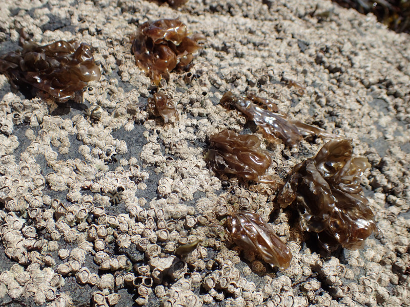
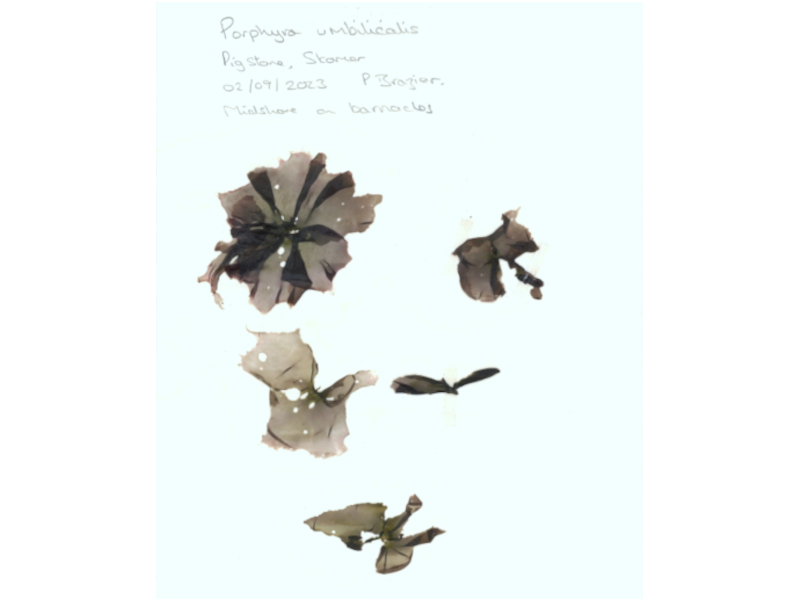
A small lettuce-like red seaweed composed of ear-shaped to wedge-shaped blades, up to 13 cm long by 10 cm wide, that grow from a minute but strong discoid holdfast. The blades feel like thick polythene to the touch but are one cell thick and translucent. The fronds are dark reddish-brown but olive green or grey in colour closer to the holdfast; brownish-purple when dry. Single blades may appear rounded where they arise from the holdfast while multiple blades may form a rosette. The blades may also appear pleated at the edges.
Recorded distribution in Britain and Ireland
Abundant on rocky shores throughout Britain and Ireland.
Global distribution
A North Atlantic species, recorded from the Arctic, south to the coast of Spain in the western Atlantic and Connecticut in the eastern Atlantic. It is also recorded from South America, Asia and Australasia (AlgalBase). However, it may have been misidentified throughout its range, and its global distribution requires review (Brodie et al., 2008).
Habitat
Tough laver grows on hard substrata such as bedrock, boulders, wood and concrete but can also be epizoic on mussels, limpets, and barnacles or epiphytic on fucoids. It is found throughout the intertidal but is most abundant on the upper shore.
Depth range
-Identifying features
- A small red seaweed, up to 13 cm long
- Tough ear-shaped to wedge-shaped frond
- Small disc-like holdfast
- A polythene-like texture
Additional information
The lavers may be difficult to identify. Porphyra umbilicalis (tough laver) may be confused with Porphya purpurea (purple laver) but is distinguished by its grey colour around the holdfasts; or with Porphyra dioica (black laver) but has a more crispy texture; or with Porphyra linearis (winter layer) but lacks a stipe and has a darker colour (for details see Bunker et al., 2017).
Listed by
- none -
Bibliography
Brodie, J., Irvine, L., Neefus, C.D. & Russell, S., 2008. Ulva umbilicalis L. and Porphyra umbilicalis Kütz. (Rhodophyta, Bangiaceae): a molecular and morphological redescription of the species, with a typification update. Taxon, 57 (4), 1328-1331. DOI https://doi.org/10.1002/tax.574022
Brodie, J., Wilbraham, J., Maggs, C.A., Baldock, L., Bunker, F., Mieszkowska, N., Scanlan, C., Tittley, I., Wilkinson, M. & Yesson, C., 2023. Red List for British seaweeds: evaluating the IUCN methodology for non-standard marine organisms. Biodiversity and Conservation, 32 (12), 3825-3843. DOI http://doi.org/10.1007/s10531-023-02649-0
Bunker, F.StD.P., Brodie, J.A., Maggs, C.A. & Bunker, A.R., 2017. Seasearch Guide to Seaweeds of Britain and Ireland (Second edition). Plymouth: Wild Nature Press.
Connor, D.W., Brazier, D.P., Hill, T.O., & Northen, K.O., 1997b. Marine biotope classification for Britain and Ireland. Vol. 1. Littoral biotopes. Joint Nature Conservation Committee, Peterborough, JNCC Report no. 229, Version 97.06., Joint Nature Conservation Committee, Peterborough, JNCC Report No. 230, Version 97.06.
Dickinson, C.I., 1963. British seaweeds. London & Frome: Butler & Tanner Ltd.
Guiry, M.D. & Guiry, G.M., 2008. AlgaeBase. http://www.algaebase.org, 2008-02-21
Hardy, F.G. & Guiry, M.D., 2003. A check-list and atlas of the seaweeds of Britain and Ireland. London: British Phycological Society
Hayward, P., Nelson-Smith, T. & Shields, C. 1996. Collins pocket guide. Sea shore of Britain and northern Europe. London: HarperCollins.
Hiscock, S., 1986b. A field key to the British Red Seaweeds. Taunton: Field Studies Council. [Occasional Publication No.13]
Howson, C.M. & Picton, B.E., 1997. The species directory of the marine fauna and flora of the British Isles and surrounding seas. Belfast: Ulster Museum. [Ulster Museum publication, no. 276.]
JNCC (Joint Nature Conservation Committee), 1999. Marine Environment Resource Mapping And Information Database (MERMAID): Marine Nature Conservation Review Survey Database. [on-line] http://www.jncc.gov.uk/mermaid
Norton, T.A. (ed.), 1985. Provisional Atlas of the Marine Algae of Britain and Ireland. Huntingdon: Biological Records Centre, Institute of Terrestrial Ecology.
Picton, B.E. & Costello, M.J., 1998. BioMar biotope viewer: a guide to marine habitats, fauna and flora of Britain and Ireland. [CD-ROM] Environmental Sciences Unit, Trinity College, Dublin.
Datasets
Centre for Environmental Data and Recording, 2018. Ulster Museum Marine Surveys of Northern Ireland Coastal Waters. Occurrence dataset https://www.nmni.com/CEDaR/CEDaR-Centre-for-Environmental-Data-and-Recording.aspx accessed via NBNAtlas.org on 2018-09-25.
Environmental Records Information Centre North East, 2018. ERIC NE Combined dataset to 2017. Occurrence dataset: http://www.ericnortheast.org.ukl accessed via NBNAtlas.org on 2018-09-38
Fenwick, 2018. Aphotomarine. Occurrence dataset http://www.aphotomarine.com/index.html Accessed via NBNAtlas.org on 2018-10-01
Fife Nature Records Centre, 2018. St Andrews BioBlitz 2014. Occurrence dataset: https://doi.org/10.15468/erweal accessed via GBIF.org on 2018-09-27.
Fife Nature Records Centre, 2018. St Andrews BioBlitz 2015. Occurrence dataset: https://doi.org/10.15468/xtrbvy accessed via GBIF.org on 2018-09-27.
Fife Nature Records Centre, 2018. St Andrews BioBlitz 2016. Occurrence dataset: https://doi.org/10.15468/146yiz accessed via GBIF.org on 2018-09-27.
Kent Wildlife Trust, 2018. Biological survey of the intertidal chalk reefs between Folkestone Warren and Kingsdown, Kent 2009-2011. Occurrence dataset: https://www.kentwildlifetrust.org.uk/ accessed via NBNAtlas.org on 2018-10-01.
Kent Wildlife Trust, 2018. Kent Wildlife Trust Shoresearch Intertidal Survey 2004 onwards. Occurrence dataset: https://www.kentwildlifetrust.org.uk/ accessed via NBNAtlas.org on 2018-10-01.
Lancashire Environment Record Network, 2018. LERN Records. Occurrence dataset: https://doi.org/10.15468/esxc9a accessed via GBIF.org on 2018-10-01.
Manx Biological Recording Partnership, 2017. Isle of Man wildlife records from 01/01/2000 to 13/02/2017. Occurrence dataset: https://doi.org/10.15468/mopwow accessed via GBIF.org on 2018-10-01.
Manx Biological Recording Partnership, 2018. Isle of Man historical wildlife records 1995 to 1999. Occurrence dataset: https://doi.org/10.15468/lo2tge accessed via GBIF.org on 2018-10-01.
Merseyside BioBank., 2018. Merseyside BioBank (unverified). Occurrence dataset: https://doi.org/10.15468/iou2ld accessed via GBIF.org on 2018-10-01.
National Trust, 2017. National Trust Species Records. Occurrence dataset: https://doi.org/10.15468/opc6g1 accessed via GBIF.org on 2018-10-01.
NBN (National Biodiversity Network) Atlas. Available from: https://www.nbnatlas.org.
North East Scotland Biological Records Centre, 2017. NE Scotland fungus and lichen records 1800-2010. Occurrence dataset: https://doi.org/10.15468/v6mt0g accessed via GBIF.org on 2018-10-01.
OBIS (Ocean Biodiversity Information System), 2025. Global map of species distribution using gridded data. Available from: Ocean Biogeographic Information System. www.iobis.org. Accessed: 2025-08-08
Royal Botanic Garden Edinburgh, 2018. Royal Botanic Garden Edinburgh Herbarium (E). Occurrence dataset: https://doi.org/10.15468/ypoair accessed via GBIF.org on 2018-10-02.
South East Wales Biodiversity Records Centre, 2018. SEWBReC Algae and allied species (South East Wales). Occurrence dataset: https://doi.org/10.15468/55albd accessed via GBIF.org on 2018-10-02.
South East Wales Biodiversity Records Centre, 2018. Dr Mary Gillham Archive Project. Occurance dataset: http://www.sewbrec.org.uk/ accessed via NBNAtlas.org on 2018-10-02
Citation
This review can be cited as:
Last Updated: 25/06/2024


