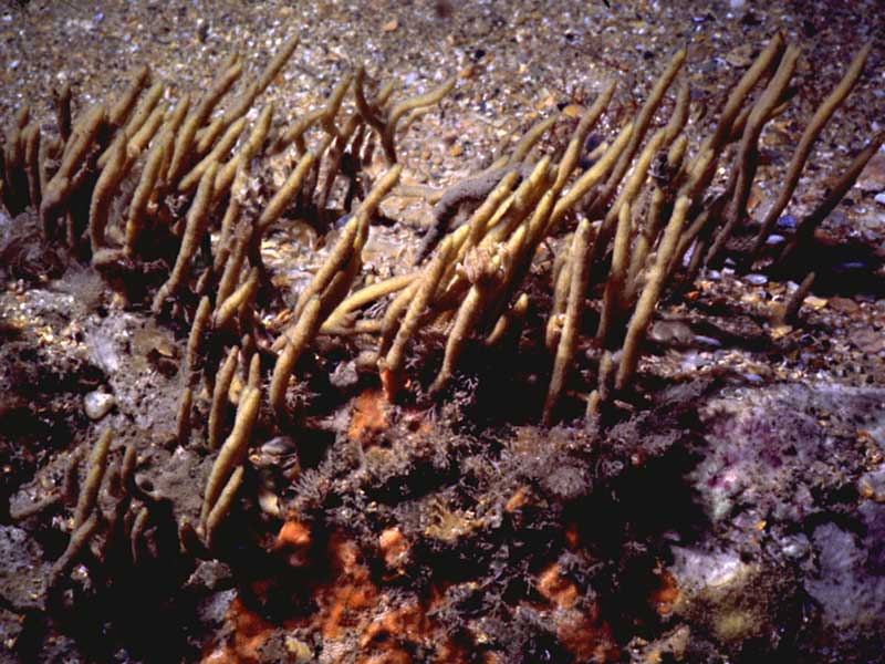
A sponge (Adreus fascicularis)
Distribution data supplied by the Ocean Biodiversity Information System (OBIS). To interrogate UK data visit the NBN Atlas.Map Help
| Researched by | Penny Avant | Refereed by | Admin |
| Authority | (Bowerbank, 1866) | ||
| Other common names | - | Synonyms | Dictyocylindrus fascicularis (Bowerbank, 1866) |
Summary
Description
Recorded distribution in Britain and Ireland
Rare around the southwest coast of England, reported from Lyme Bay, Dorset, Plymouth, Devon and around the coast of Lundy.Global distribution
-Habitat
Found sublittorally, at a depth of 10 - 30 m, on sand-covered rock.Depth range
-Identifying features
- An arborescent sponge growing up to about 12 cm in height.
- The slender, cylindrical branches are smooth.
- Amber-yellow in colour.
Additional information
No text enteredListed by
- none -
Bibliography
Bowerbank, J.S., 1865. A monograph of the British Spongiadae, vol. II. London: Ray Society.
Bowerbank, J.S., 1874. A monograph of the British Spongiadae, vol. lll. London: Hardwicke.
Hiscock, K., Stone, S.M.K. & George, J.D., 1983. The marine fauna of Lundy. Porifera (sponges): a preliminary study. Report of the Lundy Field Society, 134, 16-35.
Howson, C.M. & Picton, B.E., 1997. The species directory of the marine fauna and flora of the British Isles and surrounding seas. Belfast: Ulster Museum. [Ulster Museum publication, no. 276.]
JNCC (Joint Nature Conservation Committee), 1999. Marine Environment Resource Mapping And Information Database (MERMAID): Marine Nature Conservation Review Survey Database. [on-line] http://www.jncc.gov.uk/mermaid
Datasets
NBN (National Biodiversity Network) Atlas. Available from: https://www.nbnatlas.org.
OBIS (Ocean Biodiversity Information System), 2025. Global map of species distribution using gridded data. Available from: Ocean Biogeographic Information System. www.iobis.org. Accessed: 2025-08-08
Citation
This review can be cited as:
Last Updated: 21/06/2002


