Common reed (Phragmites australis)
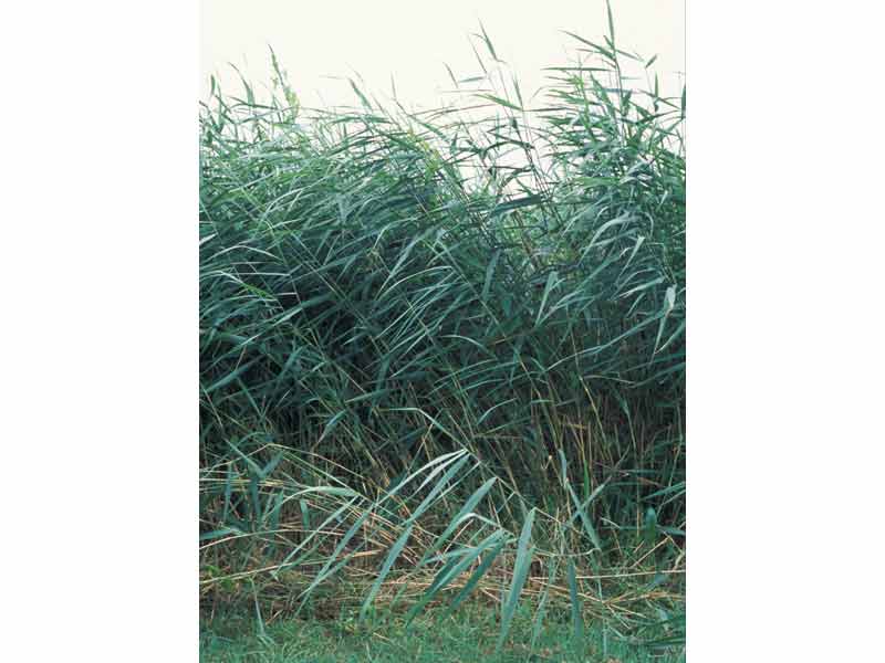
A stand of Phragmites australis.
Photographer: Harvey Tyler-Walters Copyright: Dr Harvey Tyler-Walters
Distribution data supplied by the Ocean Biodiversity Information System (OBIS). To interrogate UK data visit the NBN Atlas.Map Help
| Researched by | Dr Harvey Tyler-Walters | Refereed by | Admin |
| Authority | (Cav.) Trin. ex Steud. | ||
| Other common names | - | Synonyms | Phragmites communis (Cav.) Trin. ex Steud. |
Summary
Description
Recorded distribution in Britain and Ireland
Common throughout the British Isles, especially in the south and east but more scattered in the north and west (only coastal records shown on map).Global distribution
Cosmopolitan from Finnmark Norway, south to Africa. Uncommon in tropical Africa and recorded from America south to the Amazon basin. Recorded as non-native in New Zealand, Australia and Polynesia.Habitat
Forms extensive stands on mud or in shallow water in marshes, fens, bogs, and the edges of shallow lakes, salt marshes and estuaries.Depth range
-Identifying features
- A tall reed up to 4m high above water level with an extensive rhizome system.
- Stems round and hollow.
- Leaves attached to stem by a smooth sheath with a fringe of hairs next to stem.
- Flowers borne on a very long, many branched inflorescence, purple in colour.
- Branches between florets bear long, white, silky hairs.
Additional information
Phragmites australis is a characteristic tall reed with a large purple inflorescence, however, accurate identification requires an examination of the structure of the inflorescence and flowers (for details see Haslam, 1972; Stace, 1999). The common reed is harvested primarily for use in thatching in Britain but has numerous uses worldwide (Haslam, 1972). Phragmites australis is the dominant species in reedbeds, a UK BAP habitat, and amongst the most important habitat for birds in the UK such as the bittern, the reed bunting and the marsh harrier (Anon, 1995; Hawke & José, 1996).Listed by
- none -
Bibliography
Anonymous, 1995. Reedbeds. A costed Habitat Action Plan. In Biodiversity: The UK Steering Group Report - Volume II: Action Plans (The UK Biodiversity Steering Group), pp. 230-232., London: HMSO
Cronquist, A., 1988. The evolution and classification of flowering plants (2nd edn). New York: New York Botanical Garden.
Haslam, S.M., 1972. Biological flora of the British Isles. Phragmites communis Trin. Journal of Ecology, 60, 585-610.
Hawke, C.J. & José, P.V., 1996. Reedbed management for commercial and wildlife interests. Sandy, Bedfordshire: Royal Society for the Protection of Birds (RSPB).
Stace, C., 1999. Field flora of the British Isles. Cambridge: Cambridge University Press.
Datasets
Botanical Society of Britain & Ireland, 2018. Other BSBI Scottish data up to 2012. Occurrence dataset: https://doi.org/10.15468/2dohar accessed via GBIF.org on 2018-09-25.
Botanical Society of Britain & Ireland, 2018. Scottish SNH-funded BSBI records. Occurrence dataset: https://doi.org/10.15468/llasrt accessed via GBIF.org on 2018-09-25.
Botanical Society of Britain & Ireland, 2018. Welsh BSBI data (ex-VPDB dataset) at hectad resolution. Occurrence dataset: https://doi.org/10.15468/rsvnif accessed via GBIF.org on 2018-09-25.
Bristol Regional Environmental Records Centre, 2017. BRERC species records recorded over 15 years ago. Occurrence dataset: https://doi.org/10.15468/h1ln5p accessed via GBIF.org on 2018-09-25.
Bristol Regional Environmental Records Centre, 2017. BRERC species records within last 15 years. Occurrence dataset: https://doi.org/10.15468/vntgox accessed via GBIF.org on 2018-09-25.
Cofnod – North Wales Environmental Information Service, 2018. Miscellaneous records held on the Cofnod database. Occurrence dataset: https://doi.org/10.15468/hcgqsi accessed via GBIF.org on 2018-09-25.
Derbyshire Wildlife Trust, 2017. Vascular Plant Records up to 2010. Occurrence dataset: https://doi.org/10.15468/u5rceu accessed via GBIF.org on 2018-09-25.
Dorset Environmental Records Centre, 2017. Dorset Sites of Nature Conservation Interest (SNCI) species records 2000-2008. Occurrence dataset: https://doi.org/10.15468/r1ebqb accessed via GBIF.org on 2018-09-25.
Dorset Environmental Records Centre, 2017. Dorset Sites of Nature Conservation Interest (SNCI) species records pre 2000. Occurrence dataset: https://doi.org/10.15468/qyg29v accessed via GBIF.org on 2018-09-25.
Dorset Environmental Records Centre, 2017. Dorset SSSI Species Records 1952 - 2004 (Natural England). Occurrence dataset: https://doi.org/10.15468/vcjzts accessed via GBIF.org on 2018-09-25.
Dorset Environmental Records Centre, 2018. Bryophyte Survey of the Poole Basin Mires - NBN South West Pilot Project Case Studies. Occurrence dataset: https://doi.org/10.15468/eklhxs accessed via GBIF.org on 2018-09-25.
Environmental Records Information Centre North East, 2018. ERIC NE Combined dataset to 2017. Occurrence dataset: http://www.ericnortheast.org.ukl accessed via NBNAtlas.org on 2018-09-38
Essex Wildlife Trust Biological Records Centre, 2018. River Blackwater historic river corridor surveys. Occurrence dataset: https://doi.org/10.15468/bpebj2 accessed via GBIF.org on 2018-09-27.
Essex Wildlife Trust Biological Records Centre, 2018. River Blackwater historic river corridor surveys. Occurrence dataset: https://doi.org/10.15468/bpebj2 accessed via GBIF.org on 2018-09-27.
Essex Wildlife Trust Biological Records Centre, 2018. River Pant historic river corridor surveys. Occurrence dataset: https://doi.org/10.15468/4fqgcc accessed via GBIF.org on 2018-09-27.
Greater Manchester Ecology Unit, 2018. Distribution of Higher Plants in Greater Manchester. Occurrence dataset: https://www.tameside.gov.uk/ecologyunit accessed via NBNAtlas.org on 2018-09-27.
Hertfordshire Natural History Society Flora Group, 2017. Hertfordshire Flora Survey Records 1987-2005. Occurrence dataset: https://doi.org/10.15468/ntvxgr accessed via GBIF.org on 2018-09-27.
John Muir Trust, 2017. Plants, Bryophytes and Lichens recorded on Quinag in 2006-2007. Occurrence dataset: https://doi.org/10.15468/fjkkc1 accessed via GBIF.org on 2018-09-27.
Lancashire Environment Record Network, 2018. LERN Records. Occurrence dataset: https://doi.org/10.15468/esxc9a accessed via GBIF.org on 2018-10-01.
Manx Biological Recording Partnership, 2017. Isle of Man wildlife records from 01/01/2000 to 13/02/2017. Occurrence dataset: https://doi.org/10.15468/mopwow accessed via GBIF.org on 2018-10-01.
Manx Biological Recording Partnership, 2018. Isle of Man historical wildlife records 1990 to 1994. Occurrence dataset: https://doi.org/10.15468/aru16v accessed via GBIF.org on 2018-10-01.
Manx Biological Recording Partnership, 2018. Isle of Man historical wildlife records 1995 to 1999. Occurrence dataset: https://doi.org/10.15468/lo2tge accessed via GBIF.org on 2018-10-01.
Manx Biological Recording Partnership, 2022. Isle of Man historical wildlife records 1990 to 1994. Occurrence dataset:https://doi.org/10.15468/aru16v accessed via GBIF.org on 2024-09-27.
Merseyside BioBank., 2017. Merseyside BioBank (verified). Occurrence dataset: https://doi.org/10.15468/ar0p6s accessed via GBIF.org on 2018-10-01.
Merseyside BioBank., 2018. Merseyside BioBank (unverified). Occurrence dataset: https://doi.org/10.15468/iou2ld accessed via GBIF.org on 2018-10-01.
Merseyside BioBank., 2018. Merseyside BioBank Active Naturalists (unverified). Occurrence dataset: https://doi.org/10.15468/smzyqf accessed via GBIF.org on 2018-10-01.
National Trust, 2017. National Trust Species Records. Occurrence dataset: https://doi.org/10.15468/opc6g1 accessed via GBIF.org on 2018-10-01.
National Trust, 2017. Wicken Fen nature reserve species data held by The National Trust. Occurrence dataset: https://doi.org/10.15468/iqeemg accessed via GBIF.org on 2018-10-01.
National Trust, 2018. Anglesey Abbey wildlife species data held by The National Trust. Occurrence dataset: https://doi.org/10.15468/mjs49u accessed via GBIF.org on 2018-10-01.
National Trust, 2018. Hatfield Forest species data held by The National Trust.. Occurrence dataset:https://doi.org/10.15468/cghm28 accessed via GBIF.org on 2018-10-01.
National Trust, 2018. Heigham Holmes species data held by The National Trust. Occurrence dataset: https://doi.org/10.15468/wf8xpt accessed via GBIF.org on 2018-10-01.
National Trust, 2018. Ickworth Estate species data held by The National Trust. Occurrence dataset: https://doi.org/10.15468/ysjwcc accessed via GBIF.org on 2018-10-01.
National Trust, 2018. Sutton Hoo species data held by The National Trust. Occurrence dataset: https://doi.org/10.15468/4etkkx accessed via GBIF.org on 2018-10-01.
National Trust, 2018. Wimpole Estate species data held by The National Trust. Occurrence dataset: https://doi.org/10.15468/l8oy9m accessed via GBIF.org on 2018-10-01.
NBN (National Biodiversity Network) Atlas. Available from: https://www.nbnatlas.org.
Norfolk Biodiversity Information Service, 2017. NBIS Records to December 2016. Occurrence dataset: https://doi.org/10.15468/jca5lo accessed via GBIF.org on 2018-10-01.
OBIS (Ocean Biodiversity Information System), 2025. Global map of species distribution using gridded data. Available from: Ocean Biogeographic Information System. www.iobis.org. Accessed: 2025-08-08
Record, 2017. RECORD Vascular Plant Data. Occurrence dataset https://doi.org/10.15468/nmdcir accessed via GBIF.org on 2018-10-02.
Rotherham Biological Records Centre, 2017. Rotherham Biological Records Centre - Non-sensitive Records from all taxonomic groups. Occurrence dataset: https://doi.org/10.15468/d3tufo accessed via GBIF.org on 2018-10-02.
Royal Botanic Garden Edinburgh, 2018. Royal Botanic Garden Edinburgh Herbarium (E). Occurrence dataset: https://doi.org/10.15468/ypoair accessed via GBIF.org on 2018-10-02.
South East Wales Biodiversity Records Centre, 2018. SEWBReC Vascular Plants (South East Wales). Occurrence dataset: https://doi.org/10.15468/7qjujd accessed via GBIF.org on 2018-10-02.
South East Wales Biodiversity Records Centre, 2018. Dr Mary Gillham Archive Project. Occurance dataset: http://www.sewbrec.org.uk/ accessed via NBNAtlas.org on 2018-10-02
Staffordshire Ecological Record, 2017. Data from Defra Family Organisations supplied to Staffordshire Ecological Record. Occurrence dataset: https://doi.org/10.15468/giebpp accessed via GBIF.org on 2018-10-02
Staffordshire Ecological Record, 2017. SER Site-based Surveys. Occurrence dataset: https://doi.org/10.15468/h2yko0 accessed via GBIF.org on 2018-10-02.
Staffordshire Ecological Record, 2017. SER Species-based Surveys. Occurrence dataset: https://doi.org/10.15468/q8qen3 accessed via GBIF.org on 2018-10-02.
Staffordshire Ecological Record, 2017. Staffordshire Wildlife Trust Nature Reserves Inventory. Occurrence dataset: https://doi.org/10.15468/vhdows accessed via GBIF.org on 2018-10-02.
Suffolk Biodiversity Information Service., 2017. Suffolk Biodiversity Information Service (SBIS) Dataset. Occurrence dataset: https://doi.org/10.15468/ab4vwo accessed via GBIF.org on 2018-10-02.
The Wildlife Information Centre, 2017. Natalie Harmsworth's Records (2010-2016). Occurrence dataset http://www.wildlifeinformation.co.uk/. Accessed via NBNAtlas.org/ on 2018-10-02.
The Wildlife Information Centre, 2018. TWIC Biodiversity Field Trip Data (1995-present). Occurrence dataset: https://doi.org/10.15468/ljc0ke accessed via GBIF.org on 2018-10-02.
West Wales Biodiversity Information Centre, 2017. WTSWW Data: All Taxa (West Wales). Occurrence dataset: https://doi.org/10.15468/gaakk2 accessed via GBIF.org on 2018-10-02.
Yorkshire Wildlife Trust, 2018. Yorkshire Wildlife Trust - Non-sensitive records from all taxonomic groups. Occurrence dataset: https://doi.org/10.15468/2razk5 accessed via GBIF.org on 2018-10-02.
Citation
This review can be cited as:
Last Updated: 07/10/2003
