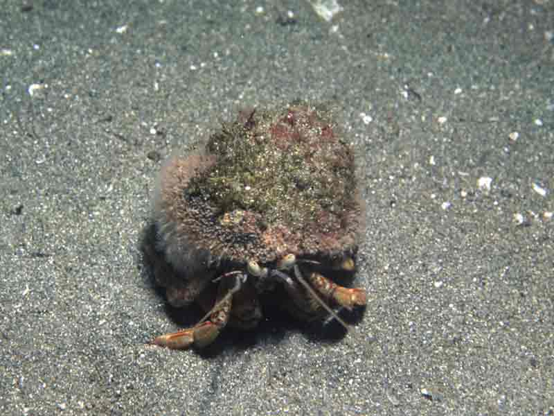
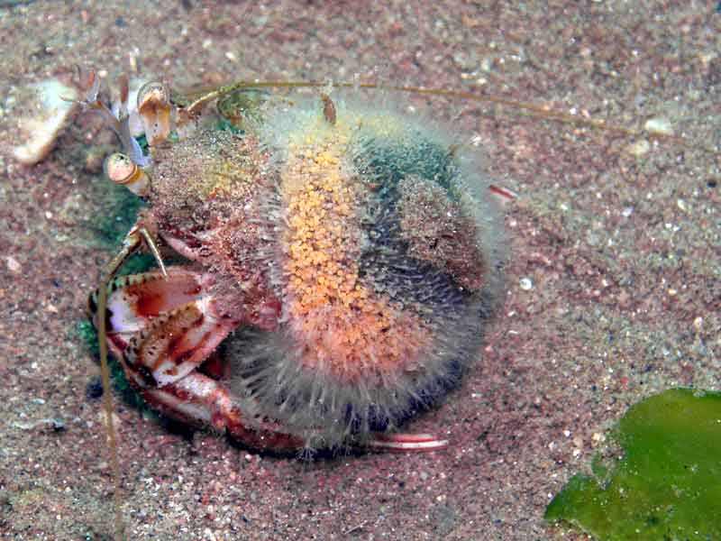
Hermit crab fur (Hydractinia echinata)
Distribution data supplied by the Ocean Biodiversity Information System (OBIS). To interrogate UK data visit the NBN Atlas.Map Help
| Researched by | Catherine MacDougall | Refereed by | Admin |
| Authority | (Fleming, 1828) | ||
| Other common names | Snail fur, Hermit crab hydroid | Synonyms | - |
Summary
Description
Forms a horny mat, the hydrorhiza, about 3 mm thick on gastropod shells occupied by hermit crabs. The mat consists of thick jagged spines that reach 3 mm in height. Amongst the hydrorhiza mat there are three types of polyps: 1) a club like feeding polyp that grows up to 13 mm in length, with upper and lower circles of eight tentacles, the lower set being shorter than the upper; 2) male and female reproductive polyps (gonozoids) that have a few short terminal tentacles, and 3) specialized defensive stinging polyps (dactylozooids) that are long coils and look thread-like. The gonozoids liberate crawling planula larvae that can sense moving gastropod shells.
Recorded distribution in Britain and Ireland
Recorded from all round Britain but sparse on the east coast.Global distribution
Common from Arctic Norway to north west Africa. Not recorded in the Mediterranean.Habitat
Lives on the shell of hermit crabs in the intertidal and subtidal.Depth range
-Identifying features
- Forms a horny mat about 3 mm thick on the back of the gastropod shells occupied by a hermit crab.
- Amongst the mat there are long feeding polyps of 13 mm in length and defensive polyps in a long coil that look thread like.
Additional information
No text entered
Listed by
- none -
Bibliography
Gibson, R., Hextall, B. & Rogers, A., 2001. Photographic guide to the sea and seashore life of Britain and north-west Europe. Oxford: Oxford University Press.
Hayward, P., Nelson-Smith, T. & Shields, C. 1996. Collins pocket guide. Sea shore of Britain and northern Europe. London: HarperCollins.
JNCC (Joint Nature Conservation Committee), 1999. Marine Environment Resource Mapping And Information Database (MERMAID): Marine Nature Conservation Review Survey Database. [on-line] http://www.jncc.gov.uk/mermaid
Datasets
Centre for Environmental Data and Recording, 2018. Ulster Museum Marine Surveys of Northern Ireland Coastal Waters. Occurrence dataset https://www.nmni.com/CEDaR/CEDaR-Centre-for-Environmental-Data-and-Recording.aspx accessed via NBNAtlas.org on 2018-09-25.
Fenwick, 2018. Aphotomarine. Occurrence dataset http://www.aphotomarine.com/index.html Accessed via NBNAtlas.org on 2018-10-01
Fife Nature Records Centre, 2018. St Andrews BioBlitz 2014. Occurrence dataset: https://doi.org/10.15468/erweal accessed via GBIF.org on 2018-09-27.
Fife Nature Records Centre, 2018. St Andrews BioBlitz 2015. Occurrence dataset: https://doi.org/10.15468/xtrbvy accessed via GBIF.org on 2018-09-27.
Fife Nature Records Centre, 2018. St Andrews BioBlitz 2016. Occurrence dataset: https://doi.org/10.15468/146yiz accessed via GBIF.org on 2018-09-27.
Kent Wildlife Trust, 2018. Kent Wildlife Trust Shoresearch Intertidal Survey 2004 onwards. Occurrence dataset: https://www.kentwildlifetrust.org.uk/ accessed via NBNAtlas.org on 2018-10-01.
Merseyside BioBank., 2018. Merseyside BioBank (unverified). Occurrence dataset: https://doi.org/10.15468/iou2ld accessed via GBIF.org on 2018-10-01.
Merseyside BioBank., 2018. Merseyside BioBank Active Naturalists (unverified). Occurrence dataset: https://doi.org/10.15468/smzyqf accessed via GBIF.org on 2018-10-01.
NBN (National Biodiversity Network) Atlas. Available from: https://www.nbnatlas.org.
North East Scotland Biological Records Centre, 2017. NE Scotland other invertebrate records 1800-2010. Occurrence dataset: https://doi.org/10.15468/ifjfxz accessed via GBIF.org on 2018-10-01.
OBIS (Ocean Biodiversity Information System), 2025. Global map of species distribution using gridded data. Available from: Ocean Biogeographic Information System. www.iobis.org. Accessed: 2025-08-08
Citation
This review can be cited as:
Last Updated: 28/01/2003


