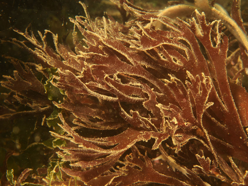
Cleaved wart weed (Gracilaria multipartita)
Distribution data supplied by the Ocean Biodiversity Information System (OBIS). To interrogate UK data visit the NBN Atlas.Map Help
| Researched by | Edward Mayhew | Refereed by | Admin |
| Authority | (Clemente) Harvey, 1846 | ||
| Other common names | - | Synonyms | Gracilaria foliifera (Forsskål) Børgesen, 1932 |
Summary
Description
Gracilaria multipartita is a translucent, dull purple or reddish-brown algae which has fronds that measure up to 25 cm long. It is cartilaginous, very brittle, and has a compressed stipe.
Recorded distribution in Britain and Ireland
Distribution in the British Isles is restricted to Cornwall, south Devon and Dorset.Global distribution
Recorded in Senegal, the Mediterranean, Nova Scotia Canada, Uruguay, the Red Sea and the Indian Ocean. Gracilaria multipartita is probably widely distributed in warmer waters.Habitat
Grows on rocks or other hard substrata, tolerating a wide degree of wave exposure. Recorded from the upper sublittoral to a depth of 15 m. Gracilaria multipartita is also tolerant of sand and mud cover.Depth range
-Identifying features
- Translucent algae, dull purple or reddish brown in colour (sometimes bleached).
- Stipe compressed, expanding gradually into a blade which is up to 1 mm thick and up to 1 cm broad between dichotomies.
- Stipe eventually branches up to 6 times in the plane of the blade.
- The margin of the blade is frequently proliferous.
Additional information
Globally there is some variation in frond-width and the degree of branching, although the appearance is quite uniform in the British Isles. Gracilaria multipartita is commercially used as an agar or agaroid raw material in the U.S.A.
Listed by
- none -
Bibliography
Dixon, P.S. & Irvine, L.M., 1977. Seaweeds of the British Isles. Volume 1 Rhodophyta. Part 1 Introduction, Nemaliales, Gigartinales. London: British Museum (Natural History) London.
Hiscock, S. & Maggs, C.A., 1982. Notes on Irish Marine Algae - 6. Zanardinia prototypus (Nardo) Nardo (Phaeophyta). Irish Naturalists' Journal, 20, 414-416.
Hiscock, S., 1986b. A field key to the British Red Seaweeds. Taunton: Field Studies Council. [Occasional Publication No.13]
Howson, C.M. & Picton, B.E., 1997. The species directory of the marine fauna and flora of the British Isles and surrounding seas. Belfast: Ulster Museum. [Ulster Museum publication, no. 276.]
JNCC (Joint Nature Conservation Committee), 1999. Marine Environment Resource Mapping And Information Database (MERMAID): Marine Nature Conservation Review Survey Database. [on-line] http://www.jncc.gov.uk/mermaid
Lincoln, R., Boxshall, G., & Clark, P., 1998. A Dictionary of Ecology, Evolution and Systematics (2nd ed.). Cambridge: Cambridge University Press
Datasets
Fenwick, 2018. Aphotomarine. Occurrence dataset http://www.aphotomarine.com/index.html Accessed via NBNAtlas.org on 2018-10-01
National Trust, 2017. National Trust Species Records. Occurrence dataset: https://doi.org/10.15468/opc6g1 accessed via GBIF.org on 2018-10-01.
NBN (National Biodiversity Network) Atlas. Available from: https://www.nbnatlas.org.
OBIS (Ocean Biodiversity Information System), 2025. Global map of species distribution using gridded data. Available from: Ocean Biogeographic Information System. www.iobis.org. Accessed: 2025-08-08
Royal Botanic Garden Edinburgh, 2018. Royal Botanic Garden Edinburgh Herbarium (E). Occurrence dataset: https://doi.org/10.15468/ypoair accessed via GBIF.org on 2018-10-02.
Citation
This review can be cited as:
Last Updated: 17/12/2002


