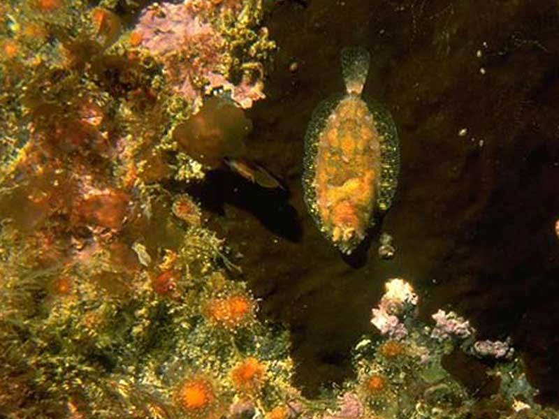
Norwegian topknot (Phrynorhombus norvegicus)
Distribution data supplied by the Ocean Biodiversity Information System (OBIS). To interrogate UK data visit the NBN Atlas.Map Help
| Researched by | Al Reeve | Refereed by | Admin |
| Authority | (Günther, 1862) | ||
| Other common names | - | Synonyms | Zeugopterus norvegicus (Günther, 1862) |
Summary
Description
Recorded distribution in Britain and Ireland
Recorded from many areas around the British and Irish coast. It is a coastal shelf species but probably under recorded since it is not caught by most fishing techniques due to its small size and habit of occurring on hard substrata.Global distribution
-Habitat
Phrynorhombus norvegicus is found living on rocks, most commonly at a depth between 20 and 50 m. However, it has been recorded in water at depths between 10 and 170 m.Depth range
-Identifying features
- Dorsal and anal fins terminate beneath the tail.
- Pelvic fins almost equal in in length and distinct from the anal fin.
- Eyes and mouth on left hand side of head.
- A yellowy-brown flatfish with irregular darker blotches on its head, back and fins.
- Moderately large scales that are smaller nearer the body edges.
- Oval to elongate fish that grows to 12 cm.
- The smallest and slenderest topknot species.
Additional information
Before metamorphosis occurs, the larvae of flatfishes are similar in appearance to those of symmetrical fish. There are occasional reversals in the direction that the eyes migrate causing the eyes to be on the opposite side of the head. However this is rare in the Norwegian topknot. The Norwegian topknot can be confused with the lemon sole (Microstomus kitt) however the lemon sole is right-eyed. The Norwegian topknot is also similar to the topknot (Zeugopterus punctatus) and Eckström's topknot (Phrynorhombus regius) however the Norwegian topknot is more slender, has a smoother snout and moderately large scales.Listed by
- none -
Bibliography
FishBase, 2000. FishBase. A global information system on fishes. [On-line] http://www.fishbase.org, 2001-05-03
Howson, C.M. & Picton, B.E., 1997. The species directory of the marine fauna and flora of the British Isles and surrounding seas. Belfast: Ulster Museum. [Ulster Museum publication, no. 276.]
JNCC (Joint Nature Conservation Committee), 1999. Marine Environment Resource Mapping And Information Database (MERMAID): Marine Nature Conservation Review Survey Database. [on-line] http://www.jncc.gov.uk/mermaid
MarLIN (Marine Life Information Network), 2005. SEArchable BEnthic Data (SEABED) Map [on-line]. Data Access Sub-programme, Marine Life Information Network for Britian and Ireland http://www.marlin.ac.uk,
Picton, B.E. & Morrow, C.C., 2000. Encyclopaedia of Marine Life of Britain and Ireland. http://www.habitas.org.uk/marinelife/index.html, 2003-09-18
Picton, B.E., & Costello, M.J., 2001. BioMar biotope viewer: a guide to marine habitats and fauna of Britain and Ireland. http://www.itsligo.ie/biomar/echinode/ECHSEP.HTM, 2001-06-01
Wheeler, A., 1969. The fishes of the British Isles and north-west Europe. London: Macmillan.
Whitehead, P.J.P., Bauchot, M.-L., Hureau, J.-C., Nielson, J. & Tortonese, E. 1986. Fishes of the North-eastern Atlantic and the Mediterranean. Vol. I, II & III. Paris: United Nations Educational, Scientific and Cultural Organisation (UNESCO).
Datasets
Manx Biological Recording Partnership, 2022. Isle of Man historical wildlife records 1990 to 1994. Occurrence dataset:https://doi.org/10.15468/aru16v accessed via GBIF.org on 2024-09-27.
NBN (National Biodiversity Network) Atlas. Available from: https://www.nbnatlas.org.
OBIS (Ocean Biodiversity Information System), 2025. Global map of species distribution using gridded data. Available from: Ocean Biogeographic Information System. www.iobis.org. Accessed: 2025-08-08
Citation
This review can be cited as:
Last Updated: 30/06/2005


