Rock goby (Gobius paganellus)

Small Gobius paganellus amongst corraline red algae in a shallow rockpool.
Photographer: Jack Sewell Copyright: Jack Sewell
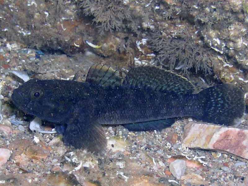
Dark breeding phase of Gobius paganellus.
Photographer: Paul Newland Copyright: Paul Newland
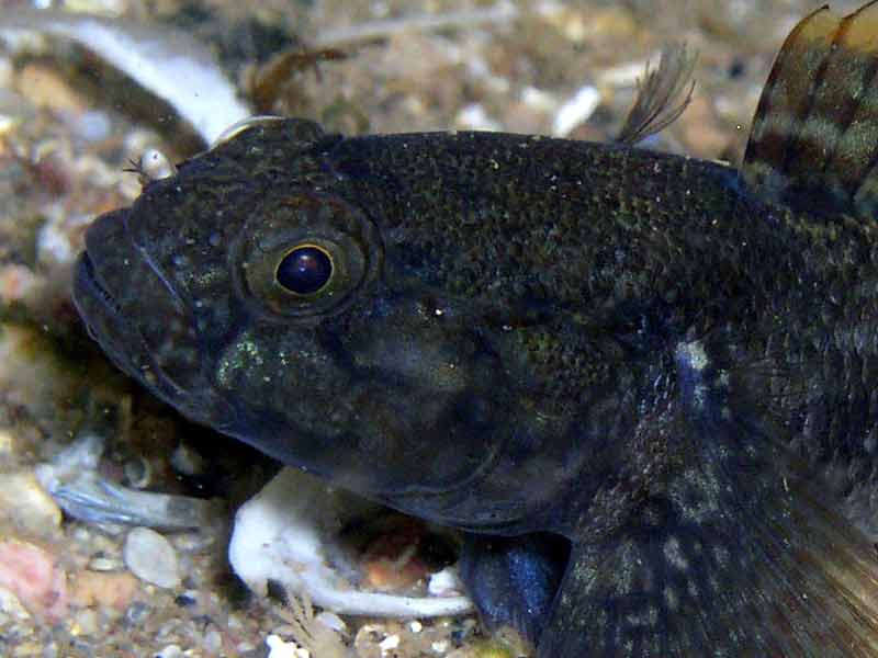
Head of Gobius paganellus during breeding phase.
Photographer: Paul Newland Copyright: Paul Newland
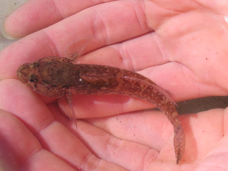
Small Gobius paganellus in a hand.
Photographer: Judith Oakley Copyright: Judith Oakley
Distribution data supplied by the Ocean Biodiversity Information System (OBIS). To interrogate UK data visit the NBN Atlas.Map Help
| Researched by | Al Reeve | Refereed by | Admin |
| Authority | Linnaeus, 1758 | ||
| Other common names | - | Synonyms | - |
Summary
Description
Recorded distribution in Britain and Ireland
Most records are from the south and west coasts of England and Scotland and around the Welsh and Irish coast. However the rock goby is likely to be found on eastern coasts where rocky outcrops are present.Global distribution
-Habitat
Gobius paganellus is present in rocky habitats from the intertidal down to around 15 m. It can be found on shores with lots of seaweed cover in rock pools and under stones.Depth range
-Identifying features
- Small in size, round in cross-section with two dorsal fins.
- Upper rays of pectoral fins reach almost to origin of dorsal fin.
- Large eyes quite close together.
- Nostrils with 5-6 finger-like protrusions.
- Pale brown with dark mottling to dark brown in colour.
- Light band on upper margin of first dorsal fin.
- Grows up to 12 cm.
Additional information
It is possible that Gobius paganellus could be confused with the giant goby (Gobius cobitis), which shares similar habitats. However, the giant goby is much larger and grows up to 27 cm. The black goby (Gobius niger) is also similar to the rock goby but the black goby is found almost exclusively on muddy or sandy substrata and has a much larger first dorsal fin.Listed by
- none -
Bibliography
FishBase, 2000. FishBase. A global information system on fishes. [On-line] http://www.fishbase.org, 2001-05-03
Howson, C.M. & Picton, B.E., 1997. The species directory of the marine fauna and flora of the British Isles and surrounding seas. Belfast: Ulster Museum. [Ulster Museum publication, no. 276.]
JNCC (Joint Nature Conservation Committee), 1999. Marine Environment Resource Mapping And Information Database (MERMAID): Marine Nature Conservation Review Survey Database. [on-line] http://www.jncc.gov.uk/mermaid
MarLIN (Marine Life Information Network), 2005. SEArchable BEnthic Data (SEABED) Map [on-line]. Data Access Sub-programme, Marine Life Information Network for Britian and Ireland http://www.marlin.ac.uk,
Picton, B.E. & Morrow, C.C., 2000. Encyclopaedia of Marine Life of Britain and Ireland. http://www.habitas.org.uk/marinelife/index.html, 2003-09-18
Picton, B.E., & Costello, M.J., 2001. BioMar biotope viewer: a guide to marine habitats and fauna of Britain and Ireland. http://www.itsligo.ie/biomar/echinode/ECHSEP.HTM, 2001-06-01
Wheeler, A., 1969. The fishes of the British Isles and north-west Europe. London: Macmillan.
Whitehead, P.J.P., Bauchot, M.-L., Hureau, J.-C., Nielson, J. & Tortonese, E. 1986. Fishes of the North-eastern Atlantic and the Mediterranean. Vol. I, II & III. Paris: United Nations Educational, Scientific and Cultural Organisation (UNESCO).
Datasets
Centre for Environmental Data and Recording, 2018. Ulster Museum Marine Surveys of Northern Ireland Coastal Waters. Occurrence dataset https://www.nmni.com/CEDaR/CEDaR-Centre-for-Environmental-Data-and-Recording.aspx accessed via NBNAtlas.org on 2018-09-25.
Cofnod – North Wales Environmental Information Service, 2018. Miscellaneous records held on the Cofnod database. Occurrence dataset: https://doi.org/10.15468/hcgqsi accessed via GBIF.org on 2018-09-25.
Fenwick, 2018. Aphotomarine. Occurrence dataset http://www.aphotomarine.com/index.html Accessed via NBNAtlas.org on 2018-10-01
Isle of Wight Local Records Centre, 2017. IOW Natural History & Archaeological Society Marine Records. Occurrence dataset: https://doi.org/10.15468/7axhcw accessed via GBIF.org on 2018-09-27.
Kent & Medway Biological Records Centre, 2017. Fish: Records for Kent. Occurrence dataset https://doi.org/10.15468/kd1utk accessed via GBIF.org on 2018-09-27.
Kent Wildlife Trust, 2018. Kent Wildlife Trust Shoresearch Intertidal Survey 2004 onwards. Occurrence dataset: https://www.kentwildlifetrust.org.uk/ accessed via NBNAtlas.org on 2018-10-01.
Lancashire Environment Record Network, 2018. LERN Records. Occurrence dataset: https://doi.org/10.15468/esxc9a accessed via GBIF.org on 2018-10-01.
National Trust, 2017. National Trust Species Records. Occurrence dataset: https://doi.org/10.15468/opc6g1 accessed via GBIF.org on 2018-10-01.
NBN (National Biodiversity Network) Atlas. Available from: https://www.nbnatlas.org.
OBIS (Ocean Biodiversity Information System), 2025. Global map of species distribution using gridded data. Available from: Ocean Biogeographic Information System. www.iobis.org. Accessed: 2025-08-08
South East Wales Biodiversity Records Centre, 2018. SEWBReC Fish (South East Wales). Occurrence dataset: https://doi.org/10.15468/htsfiy accessed via GBIF.org on 2018-10-02.
Citation
This review can be cited as:
Last Updated: 03/07/2008
