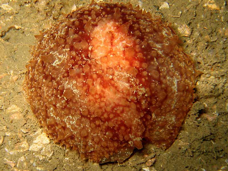
A sea slug (Geitodoris planata)
Distribution data supplied by the Ocean Biodiversity Information System (OBIS). To interrogate UK data visit the NBN Atlas.Map Help
| Researched by | Judith Oakley | Refereed by | Admin |
| Authority | (Alder & Hancock, 1846) | ||
| Other common names | - | Synonyms | Discodoris planata (Alder & Hancock, 1846), Anisodoris stellifera |
Summary
Description
Recorded distribution in Britain and Ireland
Recorded mainly on south west coasts of Britain. Uncommon on west coasts.Global distribution
Recorded from Norway to the french Biscay coast, always in shallow water.Habitat
A shallow sub-littoral species on rocky coasts that feeds on sponges e.g. Hemimycale columella.Depth range
-Identifying features
- Mantle usually brown or purple brown.
- Numerous star-shaped pale areas form loosely paired series on dorsal mantle.
- Dorsum covered by spiculose tubercles.
- Head bears conspicuous grooved, finger-like oral tentacles.
Additional information
This species was recently redescribed by Cervera et al (1985) and is now accepted as belonging to the genus Geitodoris. This uncommon species bears a superficial resemblance to the common Archidoris pseudoargus. However, Geitodoris planata is smaller, less variegated and less colourful than Archidoris pseudoargus. The oral tentacles seen in Geitodoris planata are absent in Archidoris pseudoargus. The spawn of Geitodoris planata is a broad ribbon, laid in a spiral with the upper edge neatly rippled or convoluted (Picton & Morrow, 1994).Listed by
- none -
Bibliography
Cervera, J.L., Garcia, J.C. and Garcia, F.J., 1985. Redescription of Geitodoris planata (Alder & Hancock, 1846) (Gastropoda: Nudibranchia) Journal of Mollecular Studies, 51, 198-204
Hayward, P., Nelson-Smith, T. & Shields, C. 1996. Collins pocket guide. Sea shore of Britain and northern Europe. London: HarperCollins.
Howson, C.M. & Picton, B.E., 1997. The species directory of the marine fauna and flora of the British Isles and surrounding seas. Belfast: Ulster Museum. [Ulster Museum publication, no. 276.]
JNCC (Joint Nature Conservation Committee), 1999. Marine Environment Resource Mapping And Information Database (MERMAID): Marine Nature Conservation Review Survey Database. [on-line] http://www.jncc.gov.uk/mermaid
MarLIN (Marine Life Information Network), 2005. SEArchable BEnthic Data (SEABED) Map [on-line]. Data Access Sub-programme, Marine Life Information Network for Britian and Ireland http://www.marlin.ac.uk,
Picton, B. E. & Morrow, C.C., 1994. A Field Guide to the Nudibranchs of the British Isles. London: Immel Publishing Ltd.
Rudman, W.B., 2000. Geitodoris planata [on-line]. http://seaslugforum.net/factsheet.cfm?base=geitplan,
Thompson, T. E. & Brown, G. H., 1976. British Opisthobranch Molluscs. London: Academic Press. [Synopses of the British Fauna, no. 8.]
Thompson, T.E. & Brown, G.H., 1984. Biology of Opisthobranch Molluscs, vol. II. London: Ray Society.
Datasets
Centre for Environmental Data and Recording, 2018. Ulster Museum Marine Surveys of Northern Ireland Coastal Waters. Occurrence dataset https://www.nmni.com/CEDaR/CEDaR-Centre-for-Environmental-Data-and-Recording.aspx accessed via NBNAtlas.org on 2018-09-25.
Conchological Society of Great Britain & Ireland, 2018. Mollusc (marine) data for Great Britain and Ireland - restricted access. Occurrence dataset: https://doi.org/10.15468/4bsawx accessed via GBIF.org on 2018-09-25.
Conchological Society of Great Britain & Ireland, 2023. Mollusc (marine) records for Great Britain and Ireland. Occurrence dataset: https://doi.org/10.15468/aurwcz accessed via GBIF.org on 2024-09-27.
Fenwick, 2018. Aphotomarine. Occurrence dataset http://www.aphotomarine.com/index.html Accessed via NBNAtlas.org on 2018-10-01
Manx Biological Recording Partnership, 2022. Isle of Man historical wildlife records 1990 to 1994. Occurrence dataset:https://doi.org/10.15468/aru16v accessed via GBIF.org on 2024-09-27.
NBN (National Biodiversity Network) Atlas. Available from: https://www.nbnatlas.org.
OBIS (Ocean Biodiversity Information System), 2025. Global map of species distribution using gridded data. Available from: Ocean Biogeographic Information System. www.iobis.org. Accessed: 2025-07-01
Citation
This review can be cited as:
Last Updated: 22/01/2007


