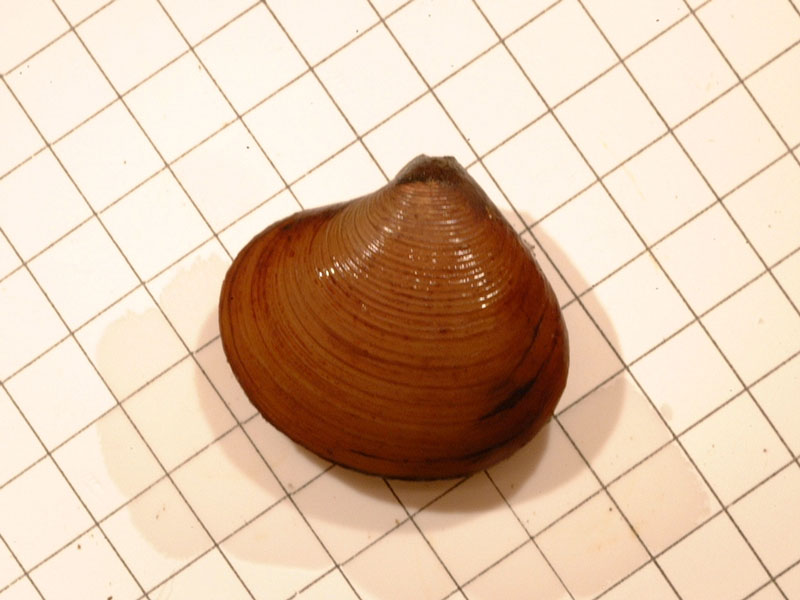
Narrow-hinge astarte (Tridonta montagui)
Distribution data supplied by the Ocean Biodiversity Information System (OBIS). To interrogate UK data visit the NBN Atlas.Map Help
| Researched by | Caroline Farrell | Refereed by | Admin |
| Authority | (Dillwyn, 1817) | ||
| Other common names | - | Synonyms | Crassina obliqua T. Brown, 1827, Venus montagui Dillwyn, 1817, Venus montacuti Turton, 1819, Venus compressa Montagu, 1808, Tridonta montagui Dillwyn, 1817, Nicania striata Leach in Ross, 1819, Nicania montagui orientalis Scarlato, 1981, Nicania montagui Dillwyn, 1817, Nicania banksii var. globosa Sars G.O., 1878, Nicania banksii Leach in Ross, 1819, Astarte abbreviata G. B. Sowerby II, 1874, Crassina convexiuscula T. Brown, 1827, Astarte pulchella Jonas in Philippi, 1845, Astarte multicostata MacGillivray, 1843, Astarte laurentiana soror Dall, 1903, Astarte laurentiana Lyell, 1845, Astarte klinti Hopner Petersen, 2001, Astarte globosa Møller, 1842, Astarte compressa Montagu, 1808, Astarte angulata Woodward, 1833 |
Summary
Description
The shell of Tridonta montagui is broadly oval in outline, with prominent umbones centred on the mid-line, and can grow up to 1.5 cm long. The outer surface is white with a thick brownish periostracum, and sculptured with 30 to 40 fine, raised concentric ridges. The inner shell margin is smooth.
Recorded distribution in Britain and Ireland
Most frequent off the north and west coasts of Britain but also recorded in the north-east.Global distribution
-Habitat
Found in sand and fine gravel from the sublittoral to depths of around 100 m.Depth range
-Identifying features
- Broadly oval, equivalve shell with prominent umbones centred on the mid-line.
- White in colour, with a thick, light or dark brown periostracum.
- Sculpture of about 30-40 broad concentric ridges and fine concentric lines.
- Distinct, elongate lunule.
- Right valve with two cardinal teeth; the anterior broad, ridged or bifid and the posterior indistinct.
- Left valve with three cardinal teeth; two anterior teeth of equal size and the third posterior tooth poorly developed and often appearing absent.
- Adductor scars and pallial line indistinct.
- Inner shell margin smooth.
Additional information
No text entered
Listed by
- none -
Bibliography
Hayward, P., Nelson-Smith, T. & Shields, C. 1996. Collins pocket guide. Sea shore of Britain and northern Europe. London: HarperCollins.
Hayward, P.J. & Ryland, J.S. (ed.) 1995b. Handbook of the marine fauna of North-West Europe. Oxford: Oxford University Press.
Howson, C.M. & Picton, B.E., 1997. The species directory of the marine fauna and flora of the British Isles and surrounding seas. Belfast: Ulster Museum. [Ulster Museum publication, no. 276.]
JNCC (Joint Nature Conservation Committee), 1999. Marine Environment Resource Mapping And Information Database (MERMAID): Marine Nature Conservation Review Survey Database. [on-line] http://www.jncc.gov.uk/mermaid
Picton, B.E. & Costello, M.J., 1998. BioMar biotope viewer: a guide to marine habitats, fauna and flora of Britain and Ireland. [CD-ROM] Environmental Sciences Unit, Trinity College, Dublin.
Tebble, N., 1976. British Bivalve Seashells. A Handbook for Identification, 2nd ed. Edinburgh: British Museum (Natural History), Her Majesty's Stationary Office.
Datasets
Conchological Society of Great Britain & Ireland, 2018. Mollusc (marine) data for Great Britain and Ireland - restricted access. Occurrence dataset: https://doi.org/10.15468/4bsawx accessed via GBIF.org on 2018-09-25.
Conchological Society of Great Britain & Ireland, 2023. Mollusc (marine) records for Great Britain and Ireland. Occurrence dataset: https://doi.org/10.15468/aurwcz accessed via GBIF.org on 2024-09-27.
Kent Wildlife Trust, 2018. Kent Wildlife Trust Shoresearch Intertidal Survey 2004 onwards. Occurrence dataset: https://www.kentwildlifetrust.org.uk/ accessed via NBNAtlas.org on 2018-10-01.
Merseyside BioBank., 2018. Merseyside BioBank (unverified). Occurrence dataset: https://doi.org/10.15468/iou2ld accessed via GBIF.org on 2018-10-01.
NBN (National Biodiversity Network) Atlas. Available from: https://www.nbnatlas.org.
OBIS (Ocean Biodiversity Information System), 2025. Global map of species distribution using gridded data. Available from: Ocean Biogeographic Information System. www.iobis.org. Accessed: 2025-07-31
Citation
This review can be cited as:
Last Updated: 26/01/2006


