A squat lobster (Galathea intermedia)
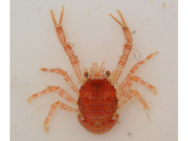
Galathea intermedia.
Photographer: Marine Ecological Surveys Ltd Copyright: Marine Ecological Surveys Ltd
Distribution data supplied by the Ocean Biodiversity Information System (OBIS). To interrogate UK data visit the NBN Atlas.Map Help
| Researched by | Dr Harvey Tyler-Walters | Refereed by | Admin |
| Authority | Lilljeborg, 1851 | ||
| Other common names | - | Synonyms | - |
Summary
Description
Galathea intermedia is the smallest of the eight squat lobster species in the UK with a maximum total length of up to 2 cm and a carapace length up to 8.5 mm. It is normally a uniform salmon-pink in colour but it can be yellowish or reddish brown, sometimes with 'neon' blue spots near the head. The basal joint of the first antenna bears two large spines instead of the usual three. The rostrum at the front of the carapace is narrow with four spines on either side. The front walking legs are as long and the body (carapace) and bear claws of similar size.
Recorded distribution in Britain and Ireland
Recorded from all coasts of the British Isles.Global distribution
Recorded from northern Norway and the North Sea, into the Kattegat and south to the Bay of Biscay, and the Atlantic coats of Spain, Portugal (and possibly Morocco), south to South Africa. Records in the Mediterranean may belong to separate sub-species (Ingle & Christiansen, 2004).Habitat
Galathea intermedia is commonly found in the subtidal but recorded from the intertidal to 100 metres on a variety of substrata, e.g. consolidated muds, sands, gravel, maerl, stones and amongst macroalgae.Depth range
Lower shore to 100 mIdentifying features
- Carapace ca 8.5 mm in length and usually salmon-red.
- Rostrum very narrow, with paired lateral teeth protruding slightly from the edge.
- Transverse post-rostral groove arched forward centrally.
- Basal joint of antenna one bears two large spines instead of the usual three.
- Small size, maximum total length up to 2 cm.
- Conspicuous anterior colouration pattern consisting of six `neon' blue spots in the frontal region of the head.
Additional information
-none-Listed by
- none -
Bibliography
Gibson, R., Hextall, B. & Rogers, A., 2001. Photographic guide to the sea and seashore life of Britain and north-west Europe. Oxford: Oxford University Press.
Ingle, R., 1997. Crayfishes, lobsters and crabs of Europe. An illustrated guide to common and traded species. London: Chapman and Hall.
Ingle, R.W. & Christiansen, M.E., 2004. Lobsters, Mud Shrimps and Anomuran Crabs: Keys and Notes for the Identification of the Species. Shrewsbury: Fields Studies Council for the Linnean Society of London and the Estuarine and Coastal Sciences Association. [Synopses of the British Fauna (New Series) No. 55].
Datasets
Environmental Records Information Centre North East, 2018. ERIC NE Combined dataset to 2017. Occurrence dataset: http://www.ericnortheast.org.ukl accessed via NBNAtlas.org on 2018-09-38
Isle of Wight Local Records Centre, 2017. IOW Natural History & Archaeological Society Marine Invertebrate Records 1853- 2011. Occurrence dataset: https://doi.org/10.15468/d9amhg accessed via GBIF.org on 2018-09-27.
Manx Biological Recording Partnership, 2022. Isle of Man historical wildlife records 1990 to 1994. Occurrence dataset:https://doi.org/10.15468/aru16v accessed via GBIF.org on 2024-09-27.
NBN (National Biodiversity Network) Atlas. Available from: https://www.nbnatlas.org.
OBIS (Ocean Biodiversity Information System), 2025. Global map of species distribution using gridded data. Available from: Ocean Biogeographic Information System. www.iobis.org. Accessed: 2025-07-30
Citation
This review can be cited as:
Last Updated: 01/12/2010
