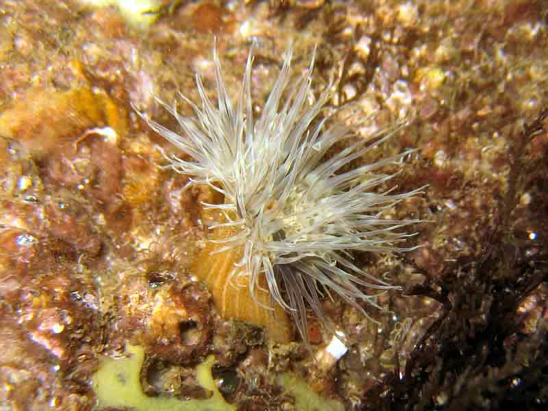
Orange-striped anemone (Diadumene lineata)
Distribution data supplied by the Ocean Biodiversity Information System (OBIS). To interrogate UK data visit the NBN Atlas.Map Help
| Researched by | Jaret Bilewitch | Refereed by | Admin |
| Authority | (Verrill, 1869) | ||
| Other common names | - | Synonyms | Haliplanella lineata |
Summary
Description
Diadumene lineata has up to 100 long tentacles arranged irregularly atop a smooth column, which is subdivided into a basal, thick-walled scaphus and a distal, thin-walled capitulum. The diameter of the column is 1-2 cm, its height is typically 1-2 cm and is coloured olive-green, with prominent orange or yellow longitudinal stripes.
Recorded distribution in Britain and Ireland
Commonly found on all coasts of Britain and in west and south west Ireland.Global distribution
Found coastally along continental Europe and along Atlantic coast of N. America, from Cape Hatteras to the Bay of Fundy. Native population exists in Japan and the Pacific Ocean.Habitat
Fouls hard substrata in harbours and brackish inshore waters. Associates with mussel and oyster shells, stones and piers. Often found intertidally. May foul hulls of boats as associate of attached bivalve shells.Depth range
-Identifying features
- 1-2 cm diameter, 1-2 cm height.
- Column olive green with yellow or orange longitudinal stripes.
- Up to 100 long tentacles, irregularly arranged.
- Column smooth, divided into scapus & capitulum.
- Acontia present.
Additional information
No text entered
Listed by
- none -
Bibliography
Datasets
Centre for Environmental Data and Recording, 2018. Ulster Museum Marine Surveys of Northern Ireland Coastal Waters. Occurrence dataset https://www.nmni.com/CEDaR/CEDaR-Centre-for-Environmental-Data-and-Recording.aspx accessed via NBNAtlas.org on 2018-09-25.
Fenwick, 2018. Aphotomarine. Occurrence dataset http://www.aphotomarine.com/index.html Accessed via NBNAtlas.org on 2018-10-01
Isle of Wight Local Records Centre, 2017. IOW Natural History & Archaeological Society Marine Invertebrate Records 1853- 2011. Occurrence dataset: https://doi.org/10.15468/d9amhg accessed via GBIF.org on 2018-09-27.
Kent Wildlife Trust, 2018. Kent Wildlife Trust Shoresearch Intertidal Survey 2004 onwards. Occurrence dataset: https://www.kentwildlifetrust.org.uk/ accessed via NBNAtlas.org on 2018-10-01.
NBN (National Biodiversity Network) Atlas. Available from: https://www.nbnatlas.org.
OBIS (Ocean Biodiversity Information System), 2025. Global map of species distribution using gridded data. Available from: Ocean Biogeographic Information System. www.iobis.org. Accessed: 2025-08-08
South East Wales Biodiversity Records Centre, 2018. INNS Data: All Taxa (South East Wales). Occurrence dataset: https://doi.org/10.15468/crhjs2 accessed via GBIF.org on 2018-10-02.
South East Wales Biodiversity Records Centre, 2023. SEWBReC Marine and other Aquatic Invertebrates (South East Wales). Occurrence dataset:https://doi.org/10.15468/zxy1n6 accessed via GBIF.org on 2024-09-27.
Citation
This review can be cited as:
Last Updated: 28/07/2009


