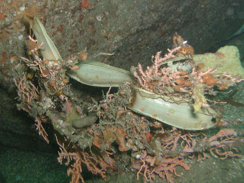
Nurse hound (Scyliorhinus stellaris)
Distribution data supplied by the Ocean Biodiversity Information System (OBIS). To interrogate UK data visit the NBN Atlas.Map Help
| Researched by | Morvan Barnes | Refereed by | Admin |
| Authority | (Linnaeus, 1758) | ||
| Other common names | - | Synonyms | - |
Summary
Description
Recorded distribution in Britain and Ireland
Found throughout Britain and Ireland from the Shetland Isles down to the coasts of Cornwall.Global distribution
-Habitat
The nurse hound occurs both inshore and offshore continental shelves, usually over rough and rocky or coralline grounds and seaweed beds, down to depths of up to 100 m. It can usually be found on or just above the seafloor.Depth range
-Identifying features
- Two dorsal fins without spines; anal fin is present.
- The first dorsal fin is larger and originates over or behind the pelvic fins.
- Five gill slits, the last of which is over the pectoral fin base.
- Back is covered in different sized black spots.
- Only small nasal flaps that do not reach the mouth.
- No nasal grooves.
Additional information
Unlike Scyliorhinus canicula it has only small anterior nasal flaps that do not reach the mouth.Listed by
Bibliography
Compagno, L.J.V., 1984. FAO species catalogue. Vol. 4. Sharks of the world. An annotated and illustrated catalogue of shark species known to date. Part 2 - Carcharhiniformes. FAO Fisheries Synopsies, 125, 251-655
Froese, R. & Pauly, D., 2007. Fishbase. A global information system on fishes. [On-line] http://www.fishbase.org, 2008-02-18
Howson, C.M. & Picton, B.E., 1997. The species directory of the marine fauna and flora of the British Isles and surrounding seas. Belfast: Ulster Museum. [Ulster Museum publication, no. 276.]
Picton, B.E. & Costello, M.J., 1998. BioMar biotope viewer: a guide to marine habitats, fauna and flora of Britain and Ireland. [CD-ROM] Environmental Sciences Unit, Trinity College, Dublin.
Datasets
Centre for Environmental Data and Recording, 2018. Ulster Museum Marine Surveys of Northern Ireland Coastal Waters. Occurrence dataset https://www.nmni.com/CEDaR/CEDaR-Centre-for-Environmental-Data-and-Recording.aspx accessed via NBNAtlas.org on 2018-09-25.
Cofnod – North Wales Environmental Information Service, 2018. Miscellaneous records held on the Cofnod database. Occurrence dataset: https://doi.org/10.15468/hcgqsi accessed via GBIF.org on 2018-09-25.
Fenwick, 2018. Aphotomarine. Occurrence dataset http://www.aphotomarine.com/index.html Accessed via NBNAtlas.org on 2018-10-01
Isle of Wight Local Records Centre, 2017. IOW Natural History & Archaeological Society Marine Records. Occurrence dataset: https://doi.org/10.15468/7axhcw accessed via GBIF.org on 2018-09-27.
Kent & Medway Biological Records Centre, 2017. Fish: Records for Kent. Occurrence dataset https://doi.org/10.15468/kd1utk accessed via GBIF.org on 2018-09-27.
Merseyside BioBank., 2018. Merseyside BioBank (unverified). Occurrence dataset: https://doi.org/10.15468/iou2ld accessed via GBIF.org on 2018-10-01.
National Trust, 2017. National Trust Species Records. Occurrence dataset: https://doi.org/10.15468/opc6g1 accessed via GBIF.org on 2018-10-01.
NBN (National Biodiversity Network) Atlas. Available from: https://www.nbnatlas.org.
OBIS (Ocean Biodiversity Information System), 2025. Global map of species distribution using gridded data. Available from: Ocean Biogeographic Information System. www.iobis.org. Accessed: 2025-08-08
Outer Hebrides Biological Recording, 2018. Vertebrates (except birds, INNS and restricted records), Outer Hebrides. Occurrence dataset: https://doi.org/10.15468/dax3tf accessed via GBIF.org on 2018-10-01.
Scottish Shark Tagging Programme, 2018. Capture Mark Recapture Data for Scottish Elasmobranchs: 2009-2018. Occurrence dataset: https://doi.org/10.15468/znol4z accessed via GBIF.org on 2018-10-02.
Citation
This review can be cited as:
Last Updated: 24/06/2008


