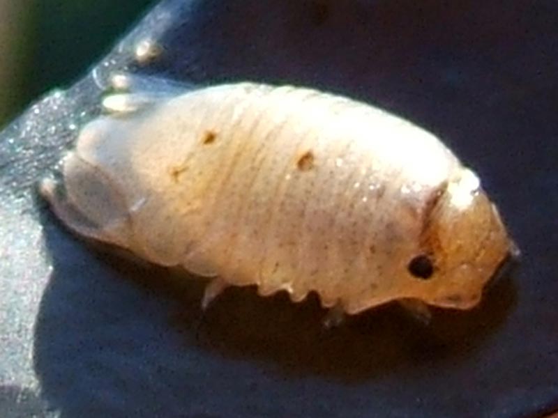
A sea slater (Lekanesphaera rugicauda)
Distribution data supplied by the Ocean Biodiversity Information System (OBIS). To interrogate UK data visit the NBN Atlas.Map Help
| Researched by | Andrew Hosie | Refereed by | Admin |
| Authority | (Leach, 1814) | ||
| Other common names | - | Synonyms | Sphaeroma rugicauda Leach 1815 |
Summary
Description
Recorded distribution in Britain and Ireland
Common in brackish waters around the UK but few records in Ireland.Global distribution
Found from the Baltic south to the Bay of Biscay and a single record from Morocco.Habitat
Lekanesphaera rugicauda is found in the upper intertidal of brackish waters. Often in salt marsh pools where it can be found burrowing or under rocks and wood.Depth range
-Identifying features
- Body broadly oval, grey typically with medial longitudinal stripe of yellow, orange or pinkish red.
- Dorsal surface of pleotelson granulated, extending beyond tips of uropods in adult males.
- Outer rami of uropod exopod almost smooth.
Additional information
There are two other species which may also be found in brackish waters in the UK and Ireland, Lekanesphaera levii and Lekanesphaera hookeri. These may be distinguished by having a smooth pleotelson and having two rows of distinct tubercles respectively, in contrast to the granulated pleotelson of Lekanesphaera rugicauda. The related species Sphaeroma serratum is not found in brackish habitats and can be distinguished by the distinctly serrate uropod exopod and a smooth pleotelson.Listed by
- none -
Bibliography
Datasets
Bristol Regional Environmental Records Centre, 2017. BRERC species records recorded over 15 years ago. Occurrence dataset: https://doi.org/10.15468/h1ln5p accessed via GBIF.org on 2018-09-25.
Cofnod – North Wales Environmental Information Service, 2018. Miscellaneous records held on the Cofnod database. Occurrence dataset: https://doi.org/10.15468/hcgqsi accessed via GBIF.org on 2018-09-25.
Environmental Records Information Centre North East, 2018. ERIC NE Combined dataset to 2017. Occurrence dataset: http://www.ericnortheast.org.ukl accessed via NBNAtlas.org on 2018-09-38
Fenwick, 2018. Aphotomarine. Occurrence dataset http://www.aphotomarine.com/index.html Accessed via NBNAtlas.org on 2018-10-01
Kent Wildlife Trust, 2018. Biological survey of the intertidal chalk reefs between Folkestone Warren and Kingsdown, Kent 2009-2011. Occurrence dataset: https://www.kentwildlifetrust.org.uk/ accessed via NBNAtlas.org on 2018-10-01.
Kent Wildlife Trust, 2018. Kent Wildlife Trust Shoresearch Intertidal Survey 2004 onwards. Occurrence dataset: https://www.kentwildlifetrust.org.uk/ accessed via NBNAtlas.org on 2018-10-01.
Merseyside BioBank., 2018. Merseyside BioBank (unverified). Occurrence dataset: https://doi.org/10.15468/iou2ld accessed via GBIF.org on 2018-10-01.
National Trust, 2017. National Trust Species Records. Occurrence dataset: https://doi.org/10.15468/opc6g1 accessed via GBIF.org on 2018-10-01.
NBN (National Biodiversity Network) Atlas. Available from: https://www.nbnatlas.org.
Norfolk Biodiversity Information Service, 2017. NBIS Records to December 2016. Occurrence dataset: https://doi.org/10.15468/jca5lo accessed via GBIF.org on 2018-10-01.
OBIS (Ocean Biodiversity Information System), 2024. Global map of species distribution using gridded data. Available from: Ocean Biogeographic Information System. www.iobis.org. Accessed: 2024-12-20
South East Wales Biodiversity Records Centre, 2018. SEWBReC Myriapods, Isopods, and allied species (South East Wales). Occurrence dataset: https://doi.org/10.15468/rvxsqs accessed via GBIF.org on 2018-10-02.
South East Wales Biodiversity Records Centre, 2018. Dr Mary Gillham Archive Project. Occurance dataset: http://www.sewbrec.org.uk/ accessed via NBNAtlas.org on 2018-10-02
Suffolk Biodiversity Information Service., 2017. Suffolk Biodiversity Information Service (SBIS) Dataset. Occurrence dataset: https://doi.org/10.15468/ab4vwo accessed via GBIF.org on 2018-10-02.
Citation
This review can be cited as:
Last Updated: 07/01/2009


